INSUBCONTINENT EXCLUSIVE:
Fatemi Firuzabadi as saying on Tuesday.The development of this sector can contribute significantly to the protection of the land and to the
development of local communities on cultural, economic, and social levels, the official explained.There are several items that must be
addressed by the tourism ministry, including identifying geotourism destinations, addressing geopark issues and solutions, diversifying
geotourism activities, and developing education and human resources for tourism, he added.Therefore, a section dedicated to geotourism has
recently been set up in the tourism ministry, he noted.A comprehensive action plan on geotourism development, as well as preparation of
regulations and instructions, should be a high priority for the tourism ministry, he mentioned.The ministry should also focus on the
conservation approach and sustainable development in geotourism, mechanisms related to planning for education, empowerment of local
communities, the provision of necessary infrastructure, advertising, introduction, and attraction of geotourists, he stated.In line for
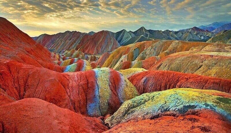
inscriptionTo develop and promote this branch of tourism, a number of Iranian geoparks including Tabas and Aras geoparks are in line for
Qeshm embraces a wide range of ecotourism attractions such as the Hara marine forests and about 60 villages dotted mostly across its rocky
The island has an abundance of wildlife, including birds, reptiles, dolphins, and turtles as well.Tabas Geopark, which is situated in a vast
region.Sprawled in the eastern province of South Khorasan, Tabas Geopark includes a variety of scenic landscapes and untouched terrains with
the mysterious Kal-e Jeni (canyon of Jinn) located in Azmighan village, among them.Situated in East Azarbaijan province, Aras Geopark covers
an area of about 1670 square kilometers, sprawling across the whole Jolfa county
The topography is generally extremely steep and forms astonishing landscapes so the highest point in the Jolfa region is the Kiyamaki mount
with 3347 meters and the lowest points include the northern boundary and the Aras River valley with 720 to 390 meters.It has an appropriate
geo-tourism attraction, because of its mountainous landscapes, an outcropping of different sedimentary and igneous rocks, diversity in
tectonic structures, semi-cold and semi-arid climate, and diverse flora and fauna.Experts believe that the majority of geoparks help promote
awareness of geological hazards, including volcanoes, earthquakes, and tsunamis and many help prepare disaster mitigation strategies with
Geoparks embody records of past climate changes and are indicators of current climate changes as well.A UNESCO Global Geopark fosters
socio-economic development that is culturally and environmentally sustainable directly affecting the area by improving human living
conditions and the rural environment
It gives local people a sense of pride in their region, strengthens public identification with the area, and promotes a better understanding
well-being of its residents.Many experts believe that geotourism is not a niche market as the global population of travelers increases and
destinations become more globalized and homogenous, principles of geotourism are resonating with travelers across the globe.ABU/MG